The IRO mantrailing test: what exam day actually looks like
You have passed the BH. At training your dog runs hour-old trails of half a kilometre and takes the junctions without you checking your watch, and someone in the gro...


There is a moment every handler knows. The dog stops, lifts its nose, turns a full circle, then pulls sideways, several metres off the line you watched the person walk. In that second you cannot tell whether it has lost the trail or has just found the scent the wind moved.
Your eyes see the route. The dog's nose meets something else: a band of scent that has drifted, broken apart against a building and pooled in places nobody stepped on. To make that difference visible, we built a search and rescue simulator that runs free in your browser and draws the physical trail and the scent still available to the dog side by side.
It is an educational tool, not an operational one. It does not predict where a missing person is and it does not tell you what your dog will do tomorrow. It does one thing, and makes it visible: it shows why the scent the dog works may not coincide with the route the person walked.
You draw the missing person's route point by point, with walking, running or stops. You choose the environment, the weather and the trail age, then start the dog. The map is measured in metres, and scent is tracked as two separate components: airborne scent, carried by the wind and deflected by buildings, and surface-bound scent, deposited on the ground and retained differently by grass, asphalt, soil, leaves or snow.
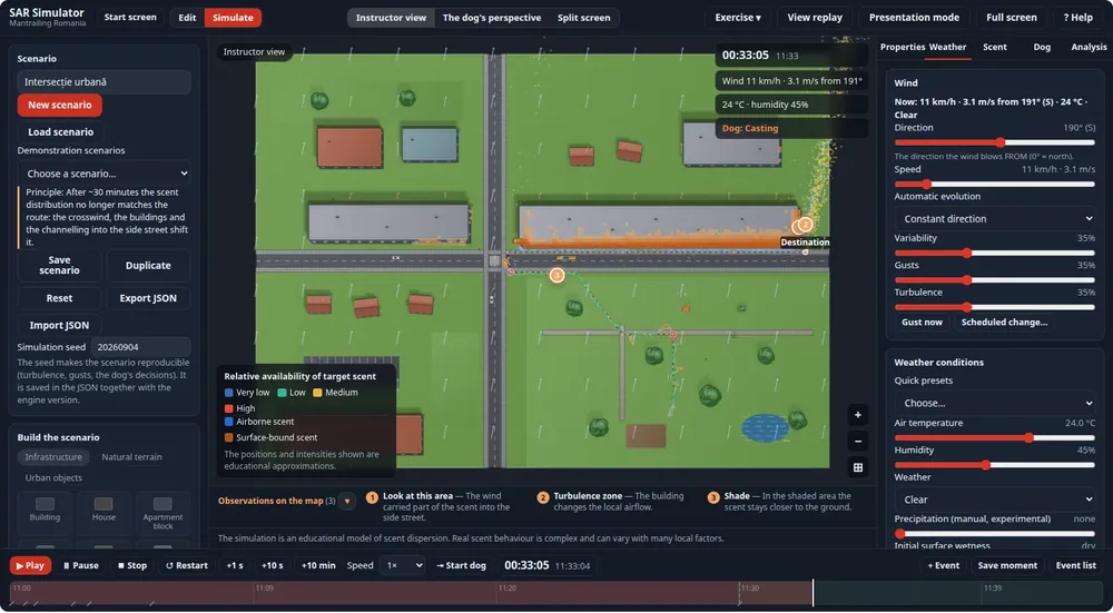
Scent values are relative, normalised into four categories from very low to high. You will not see real concentrations, because no instrument measures scent the way a dog perceives it. What you see is the relative availability of the missing person's scent at every point on the map, at the moment shown on the timeline.
The first lesson appears within seconds and it is the simplest one: a steady crosswind moves the scent band to the side of the route. In an urban scenario with an 11 km/h wind, the scent deposited on the street ends up several metres off the trail, while the airborne part turns into the side street around the corner of the building.
Buildings complicate the picture further. They deflect the airflow, leave a wind shadow behind them, channel and accelerate air between two fronts and create turbulence in the wake. Warm asphalt lifts scent by convection, while shaded areas keep it near the ground. Rain washes it down and redistributes part of it with the runoff. Each of these effects has its own demonstration scenario, so you do not have to hunt for it.
A dog working three or five metres to the side of the route, on the scent band, is working correctly. What looks like an error when you read the map with human eyes can be exactly the right decision when read with a nose. More on how weather intervenes in our article on weather conditions and scent.
Trail age is not a uniform fade. In the simulator the scent field is actually evolved through time, by transport, diffusion, deposition, re-emission, rain and decay. As a result a trail does not weaken equally on every surface: grass and soil retain far more than asphalt, and warm dry air loses scent faster than cool humid air.
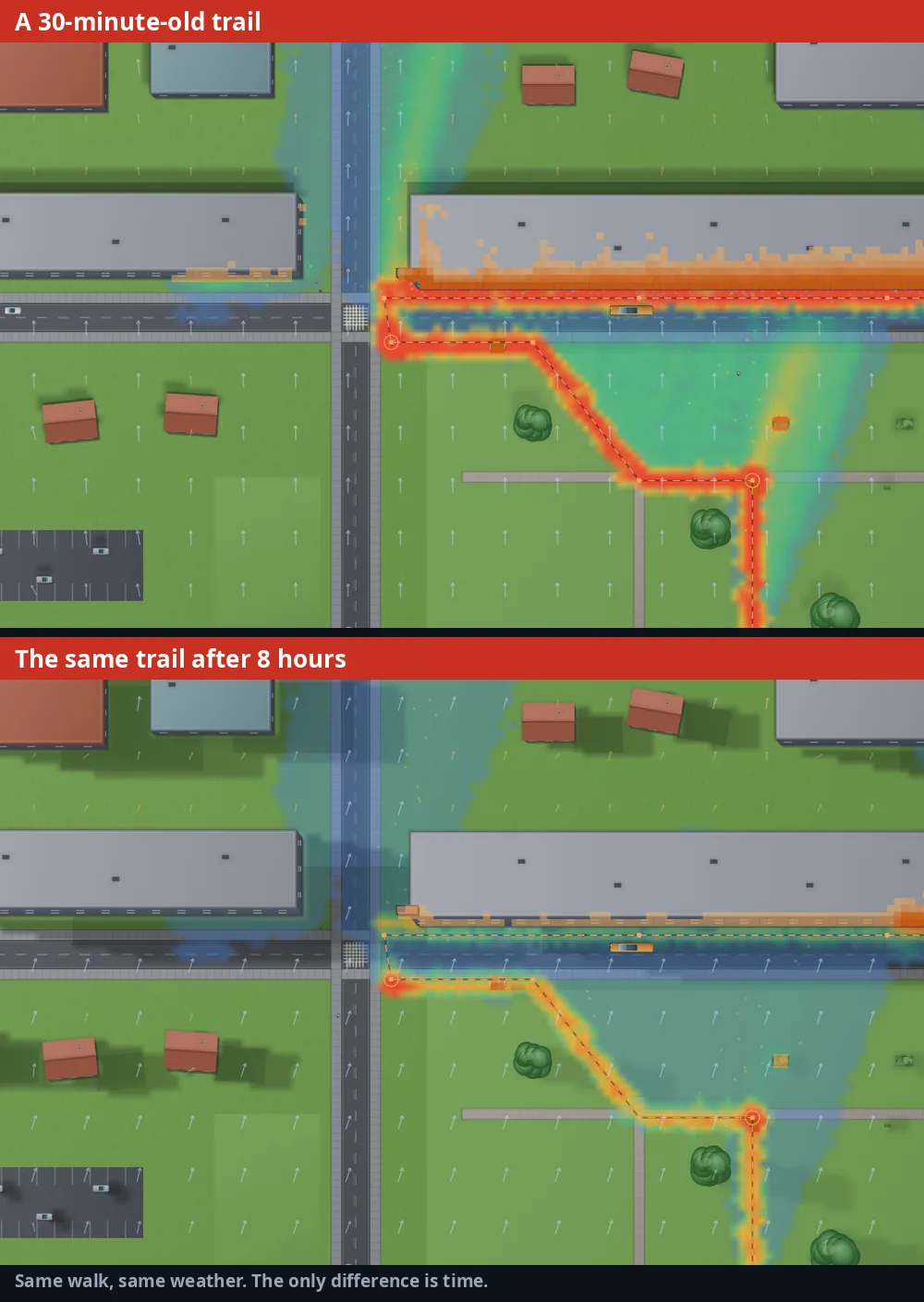
The comparison above is the same scenario, with the same weather and the same route, run once at 30 minutes and once at 8 hours. The ranges used in the model are calibrated on published studies of human scent persistence: the order of magnitude is hours on grass and sand and under three hours on asphalt, with wide variation by temperature and humidity. You can set any trail age between 5 minutes and 24 hours and watch the ageing in fast-forward, up to 60 times real speed. The topic has its own article: how long a trail lasts.
This is the part that changes how you look at a session. The simulated dog does not see the scent map. It samples locally, around its nose, and decides from the relative signal it perceives there. You can switch to its perspective, or put both views side by side.
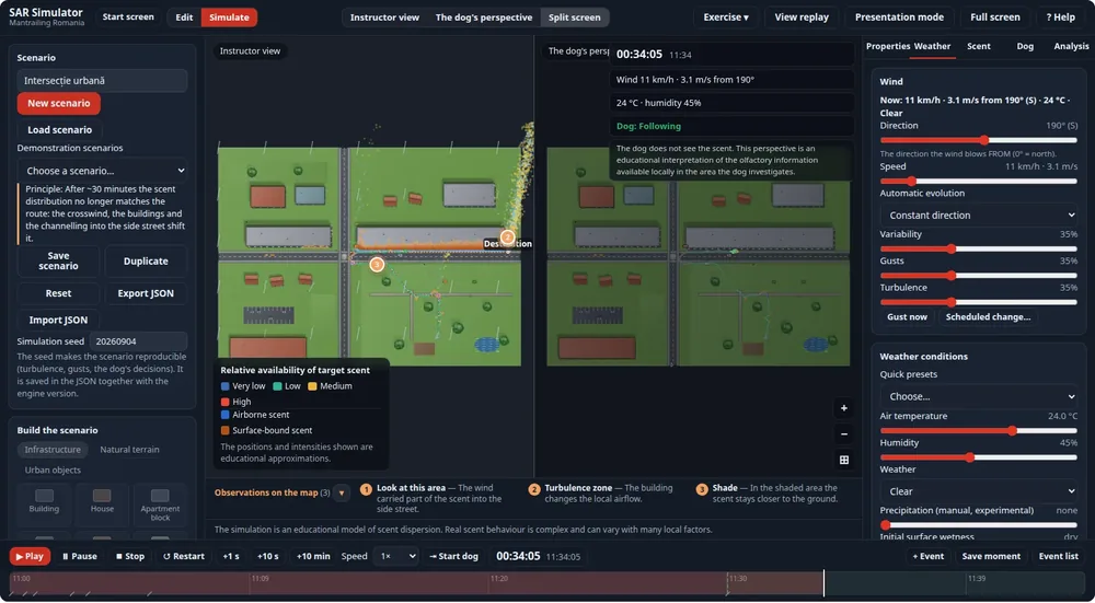
The behaviour follows three rules that hold in every scenario. At the start, the dog makes an orientation circle to pick its direction. When the signal weakens, it returns to the last good point and sweeps in concentric circles around it, avoiding obstacles. When it finds the trail again, it chooses the direction of travel from the freshness of the direct scent, not from the heading it remembered before the loss.
The states on screen, from following and checking to casting, low signal and reacquisition, are abstractions of the simulation, not behavioural diagnoses. Their value is different: they give you and your student a shared vocabulary, in real time, for behaviour that is otherwise discussed from memory after the session.
Every demonstration scenario is built to make a single effect visible: a park with no wind, a park with a crosswind, an urban intersection, a canyon between apartment blocks, after rain, heavy rain, a very hot day with hot asphalt, a cool evening, snowfall, forest, forest path junctions with shifting wind, a river ford, city into forest, hills and valley, a crowded area with scent contamination, strong wind, shifting wind, traffic carrying scent.
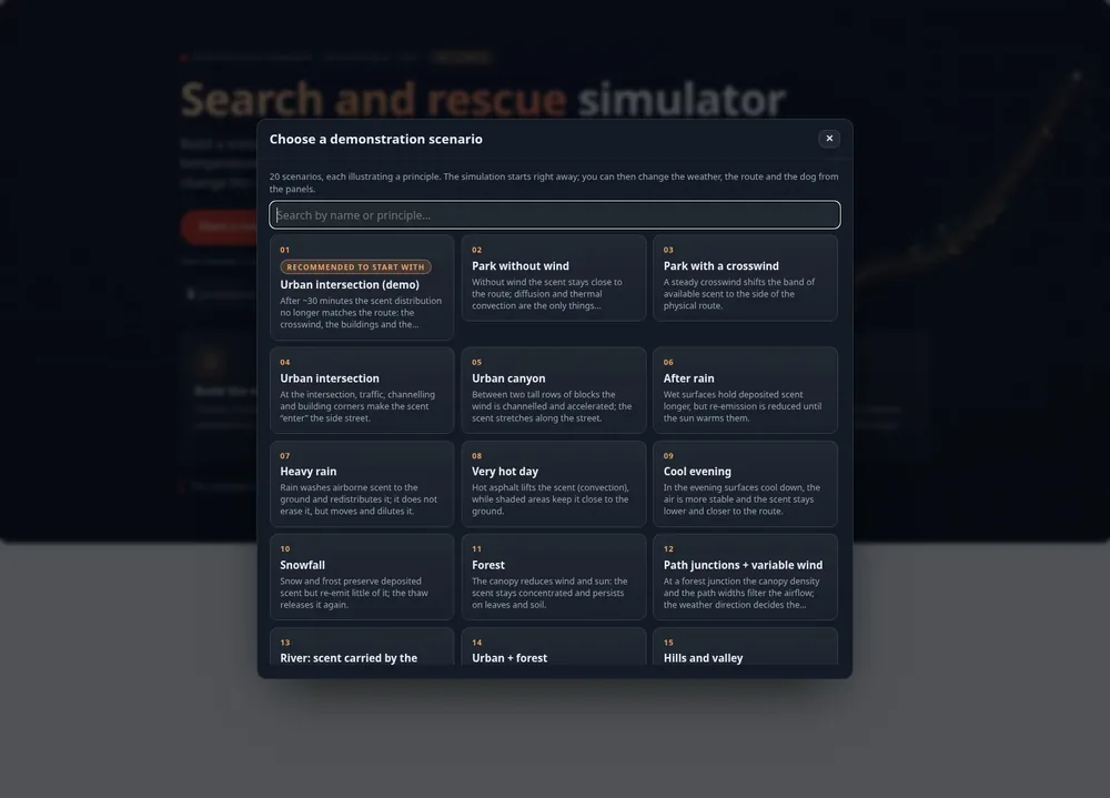
If you want something else, you build it: six generated environments plus a custom one, twelve weather presets, routes drawn by hand or generated to a given length between 30 metres and 3 kilometres. The differences between city, forest and mixed terrain are discussed separately in our article on terrain types.
The most useful thing is not watching the simulation, but using it as the starting point for a conversation. Four approaches that work:
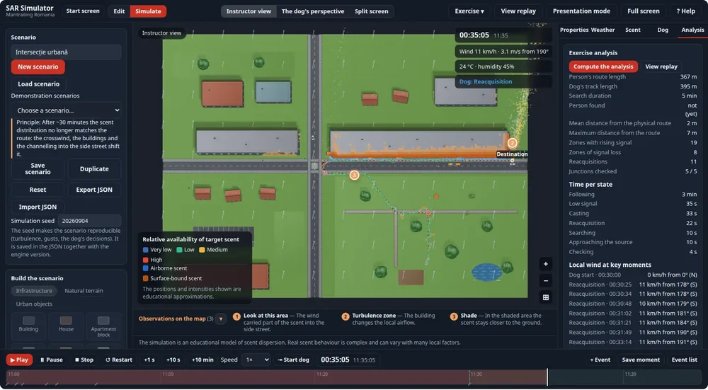
The analysis at the end is deliberately descriptive. It shows the length of the dog's track against the person's, the mean and maximum distance to the trail, the zones where the signal rose or was lost, the time spent in each state and the local wind at key moments. It gives no marks and produces no score, because a score would imply a precision the model does not have.
This is worth stating plainly, because a visual tool convinces faster than it should. The dispersion model uses simplified approximations: a global wind vector, local deflection around obstacles, wake, channelling, stochastic turbulence, relative deposition and re-emission. It does not solve the equations of air flow, it is not computational fluid dynamics and it is not a forensic prediction engine.
It models neither the chemistry of human scent nor the physiology of a particular dog. The dog profiles are sensitivity presets of the simulation, not portraits of real dogs. The practical conclusion: use it to understand the mechanisms and to talk about them, not to establish where somebody went. The biological context is explained in our article on how a dog's sense of smell works.
Open simulator.mantrailing.ro, press "Use a demonstration scenario", pick "Urban intersection" and watch. Within thirty seconds you see the difference between route and scent, and within two minutes the dog either reaches the person or gets stuck in a corner where the scent has pooled deceptively.
For everything else there is a user guide with screenshots of every screen and panel. The application runs in your browser, with no account and nothing to install, and your scenarios are saved locally. It is a beta version, in Romanian and English, and it keeps changing.
If you work in search and rescue and want the wider context, our search and rescue section covers search types, alerting and equipment.
See also on the site:
Articles
You have passed the BH. At training your dog runs hour-old trails of half a kilometre and takes the junctions without you checking your watch, and someone in the gro...
More than 3.67 million dogs in RECS, Romania's registry of owned dogs, are recorded as mixed-breed or "common breed". If uncontrolled breeding stopped today, the fir...
Around October, handlers who started mantrailing in the summer notice something odd. The dog has "improved" overnight. Forty-minute trails it lost at the first junct...
Events


