19 July 2026
Mantrailing România
It takes 7 minutes to read this article
Interactive Mantrailing App Map
How a Team from Cluj Built the SuperDogsHub App — and Why the Digital Scent Cloud Could Solve the Oldest Problem in Canine Tracking Sports
Every canine handler knows that moment of uncertainty: the dog stops, sniffs in every direction, and you, at the end of the leash, try to guess whether it has lost the trail or has simply found a place where the victim’s scent has gathered more strongly. Until now, the answer came from intuition. SuperDogsHub is trying to take it out of guesswork and put it on the map — in the form of a digitally generated scent cloud, particle by particle.
Where the Idea Started
It all began with a very specific frustration. Vlad Cotuțiu, a Doctor of Veterinary Medicine and canine sports practitioner in IPO/IGP and mantrailing since 2014, spent six months in Finland, training alongside a team from Oulu. There, he used an application called karttahimmeli for the first time, designed to provide feedback after tracking dog training sessions. The idea caught his attention — but the application had obvious limitations. After returning home, curiosity turned into a decision: if a serious solution was missing, they would build one themselves, a much more complex one.
Mantrailing
Vlad Cotuțiu (Veterinary Medicine)
Canine sports practitioner in IPO/IGP and mantrailing since 2014. He brings canine training and field expertise.
Ovidiu Someșan (Marketing & QA)
Marketing graduate, with 17 years of experience in quality assurance for devices in IT.
Andrei Bompa (IT & DevOps)
Over 15 years of experience in IT, with roles in System Administration, IT Operations, and DevOps.
Development took approximately one year before launch, and the application has already reached 14 months since its debut. Behind it is the founders’ company, AINIMAL SRL, which continues development with the same team that started the project.
The Problem No One Had Truly Solved
Anyone who has trained with a mantrailing or tracking team will recognise the situation: one phone for recording the victim’s trail, another application for live location, a third tool for planning the search perimeter — and, in the end, no one has a unified picture of what actually happened in the field.
The team identified three specific problems, observed both during their own training sessions and within other teams: fragmented working tools, the absence of any visualization of scent particle deposition, and removing the dog from the trail for the wrong reasons — the handler intervenes based on an incorrect perception of where the scent “should” be, instead of being guided by where the scent is located from a probabilistic perspective.
“Most applications in this field compare the line recorded by the victim with the line recorded by the dog — or, more accurately, by the phone in the handler’s pocket. The result is subjective by design: the real distribution of scent around that line is what matters for an objective assessment.” — the SuperDogsHub team
What the “Scent Cloud” Actually Is
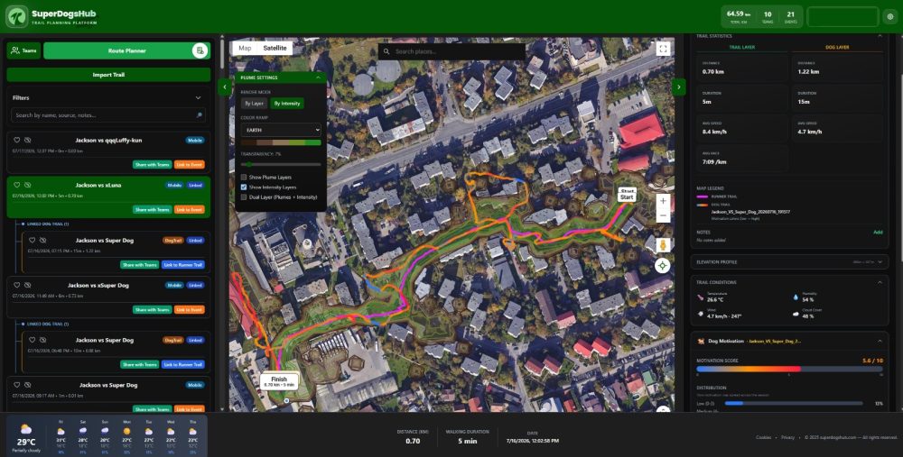
The true distinguishing feature of SuperDogsHub begins with the generation of a scent cloud based on two categories of data: what the “victim” enters into the application — wind direction and speed, the contamination level of the area — and the environmental, climatic, and biogeographical conditions of the area.
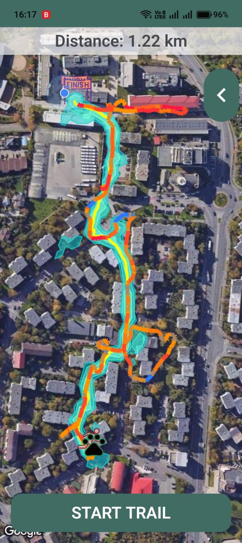
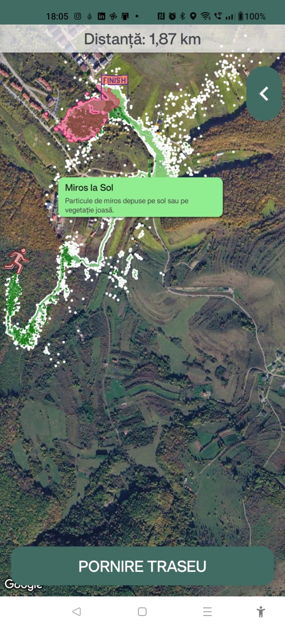
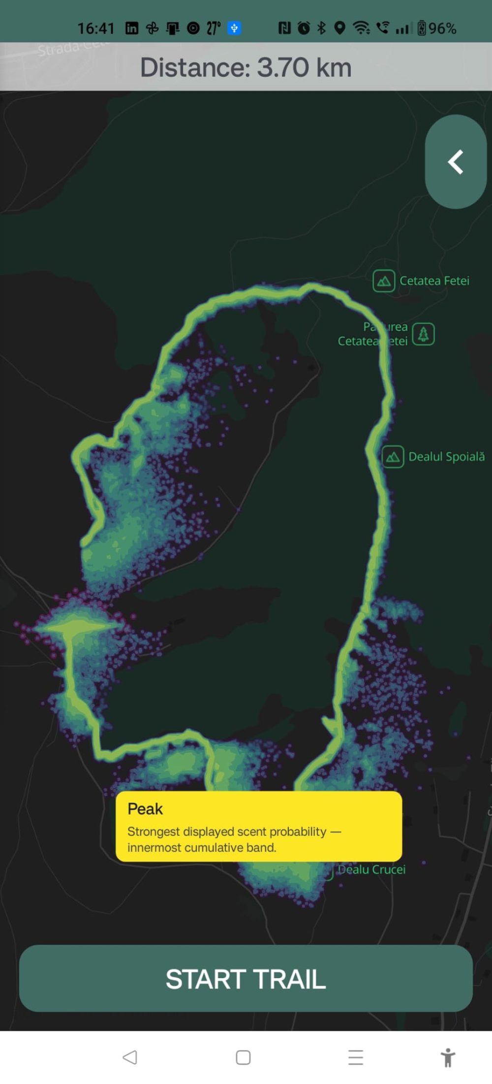
The result is a scent probability map, not a simple GPS line. The cloud can be viewed in two interchangeable ways: a surface distribution map — ground, vegetation, buildings/asphalt/infrastructure, water, air — and an intensity map, showing the areas where the scent concentration is higher.
In practice, instead of assuming where the victim’s scent may have travelled, you see a simulation based on dispersion physics — and its accuracy increases as more control points are recorded along the victim’s route.
Mantrailing
Motivation and Nose Position, the Feature Everyone Is Talking About
If the scent cloud is the foundation, the dog’s trail is the element that transforms the application from a visualization tool into a real training tool. The dog’s trail is attached directly over the victim’s trail, with two additional layers: motivation, rated from 1 to 10 and colour-coded along the route, and head/nose position — air scenting, ground scenting, or mixed.
For the handler, this means understanding exactly where the dog lost interest in relation to the cloud, not only where it stopped. For the development team, the same data becomes material for the continuous calibration of the model — field feedback directly contributes to the accuracy of the simulation.
Four Areas, One Application
Trail
The victim’s trail, with control points sent to the server for scent cloud generation
The dog’s trail, overlaid with motivation and nose position
Live location for up to 20 members simultaneously
Planning
Perimeters and up to 5 sub-perimeters inside the original perimeter
Up to 5 routes/trails to be drawn for the team per session
Pre-processing (“preheating”) of an area that has not previously been used
Team
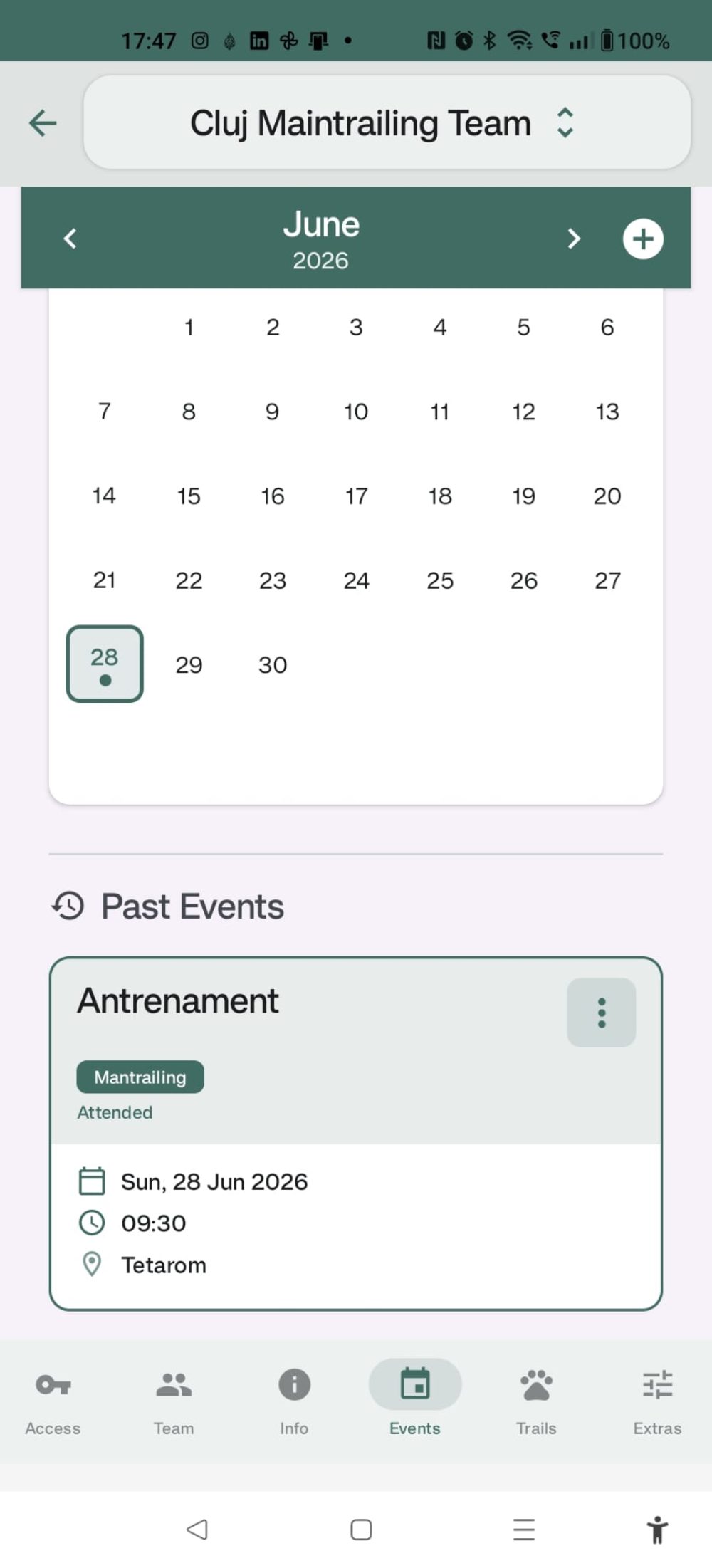
Information about the team and its members, shared event calendar
The user’s height, used to calculate emitted particles
Premium / non-premium / contributor status
The user’s own dogs, associated with the account
Platforma
From Training to a Real Mission
During training, visualizing the distribution of scent particles helps teams interpret the dog’s behaviour in both high-intensity and low-intensity areas. The application also allows the organisation of training sessions with multiple false trails or varying levels of difficulty: trail age, static areas where scent “islands” form, or areas where scent is diluted due to climatic factors.
During real operations, planning search areas and tracking the team live — including areas already covered — works on mobile devices and on PCs or laptops alike. The databases include buildings, infrastructure, roads, and paths that are outdated or not even visible on Google Maps, refreshed annually or quarterly.
Calendar
The application does not depend 100% on an internet connection: viewing already processed trails, as well as planning or recording them, remains available offline. It is currently available on Android and as a web version, with iOS testing scheduled for the beginning of September. GPX routes can be imported and exported without issues; KML export is already functional for routes and perimeters in Planner, while the remaining functionality is still being tested.
Collaboration is built in: a user can be a member of several teams simultaneously, with one real limitation — a maximum of two teams per account, subject to a premium subscription.
The Development Direction, Communicated Openly
Next month, an optional transition from Google Maps to MapLibre and OpenStreetMap is planned, intended to increase efficiency on long routes and smooth the transition between online and offline use. At the same time, a 3D version is being developed — showing particle distribution at different heights and across various surfaces — along with a Machine Learning module that will analyse existing data for much more advanced scent cloud modelling. The launch is estimated for October-November, for a limited number of participants, possibly as part of a broader research project.
In the medium term, the team wants to expand collaboration with teams and instructors internationally, as well as add features for registering for exams and seminars or purchasing courses directly through the application — and, beyond SAR/mantrailing, to make the team module available to other canine sports.
What Teams Still Want to Know Before Getting Started
Is the scent cloud an exact simulation or a probability?
It is a probabilistic simulation based on the data entered, including wind direction and speed, contamination, and the environmental conditions of the area. Accuracy increases with the number of points recorded along the victim’s trail.
Does SuperDogsHub work without an internet connection?
Partially. Viewing already processed trails, as well as planning and recording routes, also works offline.
Can trails be exported to other applications?
Yes, GPX trails can be imported and exported. KML export is available for routes and perimeters in Planner; the remaining KML functionality is still being tested.
How many people can participate in the same live location session?
Up to 20 members can participate simultaneously in the same session.
How many teams can a single user register?
A maximum of two, and registering a team requires a premium account.
On which platforms is the application available?
Android and web at present. iOS testing begins at the beginning of September.
More than 3.67 million dogs in RECS, Romania's registry of owned dogs, are recorded as mixed-breed or "common breed". If uncontrolled breeding stopped today, the fir...
More about this article →
02 October 2026
It takes 7 minutes to read this article
Around October, handlers who started mantrailing in the summer notice something odd. The dog has "improved" overnight. Forty-minute trails it lost at the first junct...
More about this article →
02 October 2026
It takes 8 minutes to read this article
On 17 and 18 October there are TSAC and FCI-BH exams in Bucharest. If you have entered, you have two weeks left. If you are aiming for the next session you have more...
We use essential cookies necessary for the proper functioning of the website. These cookies cannot be disabled. By clicking “Accept all", you agree that the Drumeții Montane Association, acting as the data controller, may store cookies on your device in order to improve website navigation, analyse website usage, and support its marketing efforts. For more details, please visit the “Cookie Settings" section available alongside.